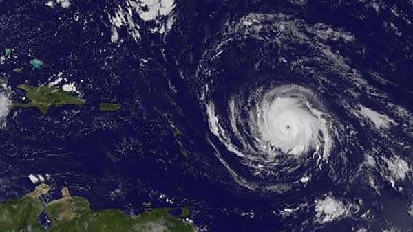
Hurricane Irma is working its way through the Caribbean today, Labor Day in Orlando and the rest of the U.S.
Forecasters expect the Category 3 hurricane with maximum sustained winds of 120 mph to remain a “dangerous major hurricane” through the week and to arrive in South Florida by Friday morning.
Modeling by the National Hurricane Center shows the outer bands of the slow-moving, potentially dangerous storm lashing Key West and Miami by 8 a.m.
Irma is continuing a slow march toward the Leeward Islands of Antigua, Barbuda, Anguilla, Montserrat and St. Kitts, which are bracing for the storm’s arrival late Tuesday or early Wednesday. The storm was located about 560 miles east of the islands, which are under a “Hurricane Warning” advisory, according to the National Hurricane Center’s 11 a.m. update.
A warning is usually issued within 36 hours of anticipated impact.
The storm is expected to strengthen over the next 48 hours as it churns west toward Puerto Rico, where a hurricane watch is in effect.
More hurricane and tropical storm watches may be issued today.
Dennis Feltgen of the National Hurricane Center in Miami said it was still too early to determine the impact on Florida.
“But people should use this time wisely to check their supplies and review their hurricane plan,” he said.
The National Meteorological Service said Puerto Rico could get prolonged high winds and as many as 8 inches of rain if the storm smacks the island Wednesday, as expected.
No hurricane warnings or watches have been issued yet in the continental U.S., but storm experts are monitoring Irma.
Florida Gov. Rick Scott urged state residents to prepare themselves for the possibility of Irma’s wrath.
“FL knows how important it is to be prepared,” he said in one tweet. “Encourage your loved ones to have a plan ahead of any potential storm. Disaster preparedness should be a priority for every Florida family.”
Irma is considered a “Cape Verde hurricane” which frequently become some of the largest and most intense storms. Hurricanes Hugo, Floyd and Ivan were Cape Verdes, forming in the far eastern Atlantic — near the Cape Verde Islands — and tracking across the ocean.
Stephen Hudak can be reached at shudak@orlandosentinel.com, 407-650-6361 or @Bearlando on Twitter.
This image from the NASA’s GOES Project shows Hurricane Irma at 3 a.m. Sept. 4, 2017. A hurricane watch is in effect for Antigua, Barbuda, Montserrat, St Kitts and other islands. The storm was packing sustained winds near 115 mph and moving west-southwest at 14 mph. (HO / AFP/Getty Images)
By www.orlandosentinel.com. Original post: http://bit.ly/2eEqoAZ
